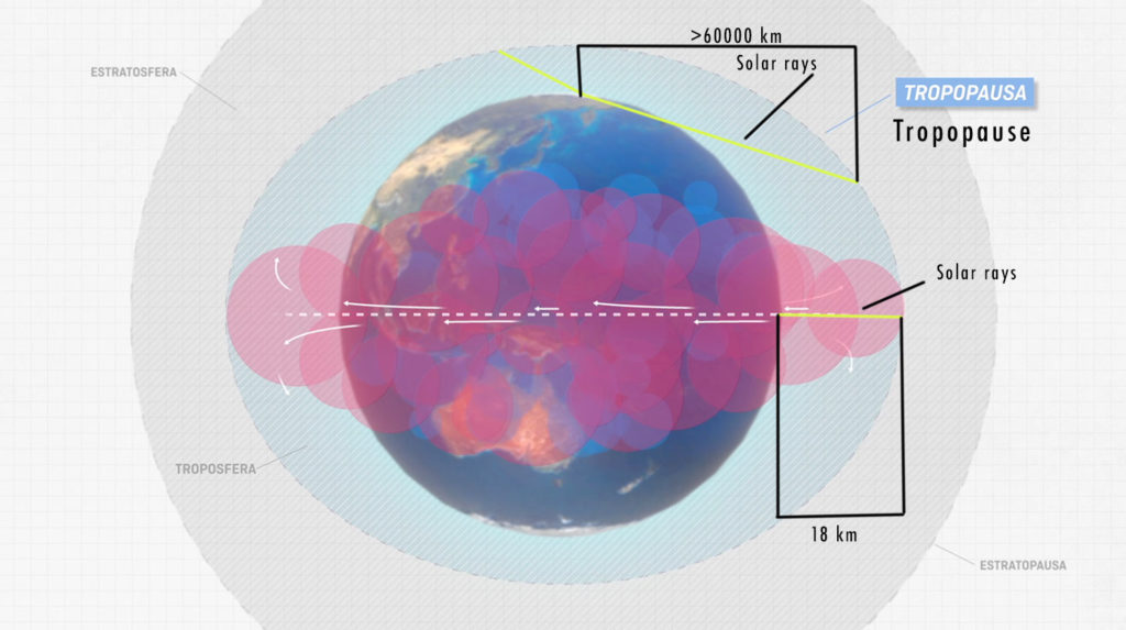
Because of the action of the Sun, the closer the air is to the Equator, the warmer it will get. As it gets warm, it expands and rises, so pressure decreases. When the air molecules reach the tropopause, they are forced to head for the poles while lowering temperature in the process. Near Parallel 30º, because of accumulation and temperature, the air comes down again compressing, heating and stacking itself, so generating high pressure.
We will explain this in a little more detail; The Sun heats the earth more at the equator than at the poles for several reasons and the first is that the equator is about 6 thousand km closer to the Sun than the poles, the rays entering the atmosphere only have to pass through a few kilometers of this before touching the ground at the equator but cross a much longer space to touch the poles as seen in the following graph and therefore arrive weaker. Another important reason is the angle with which they affect the Earth, which as we see in the graph is very different, so the rays are reflected in a different way in one point and in another.

The air when heated expands therefore has less density per cubic meter (imagine that each square of the grid in the previous graph is a cubic meter) which makes it float in relation to the more dense air. Each red bubble in the graph represents an air molecule, they all weigh the same but clearly they are of different size, so a bubble is using different number of squares, which means that in a grid column there are more or less bubbles therefore, the weight in each column is different and the larger the bubbles, the lower the weight of the column or, what is the same, the lower atmospheric pressure.
When the bubbles get at the tropopause they are forced to travel towards the poles but in reality they never reach them because they are losing temperature on the way and they start to have a higher density again, in addition to all these red bubbles (which they will now catch a colder color as you will see in the video) do not fit in the airspace of the poles since it is much smaller than the equator and as a result the air comes back down around the 30th parallel generating a high pressure, which is obviously the opposite of a low.
The lowering air is piled on itself compressing and gaining temperature, when descending it makes impossible the formation of clouds and for that reason the nonexistence of rain, for these two reasons here we have the desert areas of the planet.
As a consequence of the Earth rotation, in the Northern Hemisphere the wind will blow clockwise. Due to the accumulation of the air, pressure increases in the center of the anticyclone, so the air particles tend to travel down to low pressures though, they get turning inertia along the isobars.
Watch full video
Conclusion High and low pressures
High and low pressures refer to areas of atmospheric pressure, which are critical in determining weather patterns. Here’s a breakdown of each:
High Pressure (Anticyclone)
- Description: A high-pressure system is an area where the atmospheric pressure is higher than in the surrounding areas.
- Weather Conditions:
- Clear Skies: High-pressure systems are usually associated with clear, calm weather because they promote descending air, which inhibits cloud formation.
- Dry Conditions: They often bring dry weather, as the descending air prevents moisture from rising and condensing into clouds.
- Cooler Nights and Warmer Days: Without cloud cover, heat escapes more easily at night, leading to cooler temperatures. During the day, the lack of clouds allows more sunlight to reach the surface, warming the air.
- Movement: High-pressure systems typically move slowly and can dominate an area’s weather for several days.
Low Pressure (Cyclone)
- Description: A low-pressure system is an area where the atmospheric pressure is lower than in the surrounding areas.
- Weather Conditions:
- Cloudy and Stormy: Low-pressure systems are associated with rising air, which cools and condenses to form clouds and precipitation. This can lead to cloudy skies, rain, snow, or storms.
- Windy: Air moves from areas of high pressure to low pressure, creating winds. The closer the pressure difference, the stronger the winds.
- Unstable Weather: Low-pressure systems often bring unstable weather, including thunderstorms, hurricanes, or cyclones.
- Movement: Low-pressure systems can move quickly and often bring abrupt changes in weather.
Interaction Between High and Low Pressures
- Wind and Weather Fronts: Winds generally blow from high-pressure areas to low-pressure areas. When these systems interact, they can create weather fronts, leading to changes in temperature, humidity, and precipitation.
- Jet Streams: High and low-pressure systems are also influenced by jet streams, which are fast-moving air currents in the upper atmosphere that help steer weather systems across the globe.
Understanding these pressure systems is essential for predicting weather, as the movement and interaction of high and low-pressure areas determine the daily weather conditions experienced in different regions.
INTRO TO CANARY ISLANDS METEOROLOGY FOR FREE FLYING
Read and understand our article about flying weather in the Canary Islands.
You can also check this link for more general explanations on this topic.
If you are ready for paragliding in the Canary Islands contact us now or check our prices in this page.

